Gage Level Readings
GAGE Level Reading Interpretations (Opinions based on experience)
(Taken from a post under "Where to Paddle" but wanted the level info to be easier to find)
Here is the link to the gage followed by an example of what you will see on the site:
http://waterdata.usgs.gov/mi/nwis/uv/?site_no=04161000&PARAmeter_cd=00065,00060
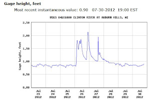
Most of our experience on the gage readings are for the Avon & Livernois (Eagles Landing) to Yates run, off hand here are some guidelines, they pretty much apply to most of the upper river runs down to Van Dyke:
http://waterdata.usgs.gov/mi/nwis/uv/?site_no=04161000&PARAmeter_cd=00065,00060

Most of our experience on the gage readings are for the Avon & Livernois (Eagles Landing) to Yates run, off hand here are some guidelines, they pretty much apply to most of the upper river runs down to Van Dyke:
1.0 - 1.25 Low level runs, A LOT of scraping on rocks and sandbars, technical because you have to follow a narrow channel (Many consider these levels too low to paddle, no fun! You can hike it!)
1.3 - 1.5 Medium level runs, should not scrape too much if any, 'advanced beginner' level and it can be a bit towards 'intermediate'when you hit a solid 1.5 on the gage. (Many consider 1.3 the lowest for the A&L to Yates section, you may want to check out Heritage/Van Dyke to Rotary/Hayes when the water is low, or further down river)
1.55 - 1.75 Medium High and approaching higher swifter water, towards the 1.7 mark you do notice swift current and it starts to become "intermediate" for sure. You should be looking ahead and anticipating the currents watching for the downstream "V's" that channel the swift water downstream.
1.8 - 2.0 High Advanced level runs, you need to know how to read the river, turn and avoid problems like obstructions (trees across the river) and strainers (trees dipping down into the river at a critical point where you can get caught like in a "strainer")
Over 2.0 is considered ADVANCED to EXPERT level runs. Problem is these levels are usually after a storm and you never know what blew down so you have to be on your toes and watching for problems.
Over 3.0 and on to 4.0 & Beyond - Flood Stage! The current is very strong and "pushy", so while most of the 'rapids' are washed out and you can pretty much float right over things, there is even more of a chance that a tree is down all the way across the river. The rapid under Rochester Road is where the river will become narrow and at high water there will be a very BIG wave/rapid/hole! In an open canoe or kayak without a skirt you will take on water if you punch through the center. (that can actually happen at some of the lower level runs too, so watch it!)
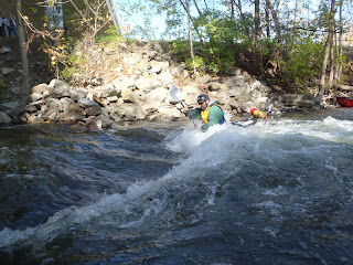
Here is a picture of Jerry Reis of Outdoor Escorts/Clinton River Kayak & Canoe doing some surfing at the Rochester Rapid!
We never blindly run the low head dam / waterfall at Yates - people have died there! As you approach the dam there will be a sign to warn you and tell you to portage on the right (River Right, if you are facing downstream "River Right" is on your Right and "River Left" is on your Left, if you turn around and face upstream, then River Right is on your Left and River Left is on your Right - Always refer to the side of the stream going downstream - got it?)

We never blindly run the low head dam / waterfall at Yates - people have died there! As you approach the dam there will be a sign to warn you and tell you to portage on the right (River Right, if you are facing downstream "River Right" is on your Right and "River Left" is on your Left, if you turn around and face upstream, then River Right is on your Left and River Left is on your Right - Always refer to the side of the stream going downstream - got it?)
Here are pictures of the signs and also someone running the dam in a whitewater boat which is outfitted for that type of run - but when the gage goes over 2.0 and 2.5 - the hydraulic becomes very strong and can suck you back in - look for a video of that in some of my older posts!


Remember, you can always "backpaddle", paddling faster 'to get around' something usually ends up putting you right into the problem. Be careful when you backpaddle too though, watch your "lean". (see below)
Another
crucial tip, besides wearing your PFD(Personal Flotation Device) is
that if you are going into a log jam or obstruction, you should "lean
into it" or "lean downstream". This is counter intuitive because you
want to turn/lean away (or lean "upstream") from a danger spot, but if
you do then the current grabs the edge of your boat and flips you. If
you lean into the obstruction you can actually brace onto it when you
impact and then the water will flow under your boat.
So the rule is "lean downstream"!
Here are pictures of someone doing the WRONG thing into an obstruction. Notice that he leaned upstream, away from the log jam. If he would have leaned into it, he could have "hand over handed" it until he got to the end of the jam and gotten by, but he leaned the WRONG WAY!


Great stuff , thanks for posting
ReplyDelete